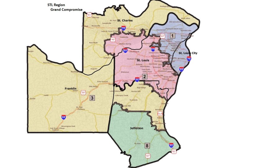
Nearly a week after failing to agree on a congressional redistricting map, House and Senate negotiators unveiled a compromise which both chambers passed Wednesday night.
The “grand compromise map” resolves sticking points over how to divvy up Jefferson County among three congressional districts and St. Charles County among two.
Scott Rupp (R, Wentzville) sponsored the map in the Missouri Senate.
“My job was to carry a map through this body that we (could) get done, and we were able to do it,” Rupp said. “We had Democrats and Republicans voting for it, you didn’t have to use any procedural motions to get people to vote on it, and this was something that got a fair up-and-down vote.”
House and Senate Republicans butted heads last week over how much of Democrat-leaning Jefferson County would be placed into the GOP-leaning southeastern Missouri district. The original Senate map had only 42,000, while the original House map had nearly 103,000 Jefferson County residents in the Eighth. Last week, both sided edged closer but still couldn’t agree. The “grand compromise” places just over 60,000 Jefferson County residents in District Eight.
Jefferson County would also be divided up among the Second and what's currently the Ninth District, which would become the Third. The current Third District would be eliminated.
All of St. Louis city would be placed in the First District, and three western rural counties, Saline, Lafayette and Ray, would be added to the urban Kansas City district. State Representative Joe Aull (D, Marshall), who happens to live in Saline County, spoke against the map on the floor of the Missouri House.
“The real map, from what I’m hearing, has been put together based on deals made by congressmen throughout the state, congressmen and congresswomen,” Aull said. “Basically we’re more or less just a rubber stamp trying to approve what they’ve come up with.”
House Democrats, in fact, are urging Governor Jay Nixon (D) to veto the redistricting map.
Although a few Democrats and Republicans broke ranks in both chambers, the House and Senate votes fell mostly along party lines.
Governor Nixon has not said yet if he’ll sign or veto the congressional redistricting map.
Updated 8:22 p.m.
The Missouri Senate has voted 27 to 7 in favor of the map. The vote there also mostly fell along party lines, with 3 Democrats voting "yes" and 2 Republicans voting "no."
The map now goes to Governor Jay Nixon (D). House Democrats are urging the governor to veto it.
Updated 7:23 p.m.
The Missouri House has voted 96 to 55 in favor of the map. The vote was mostly along party lines, though 4 Republicans voted "No" and 2 Democrats voted "Yes."
Voting on the map now goes to the Senate.
Original Story:
Missouri House and Senate negotiators on redistricting have finally reached a compromise on how to draw Missouri’s congressional map (see above).
The so-called “grand compromise map” resolves sticking points over how to divvy up Jefferson County among three congressional districts and St. Charles County among two districts.
This is a developing story, and more details will be published later.


