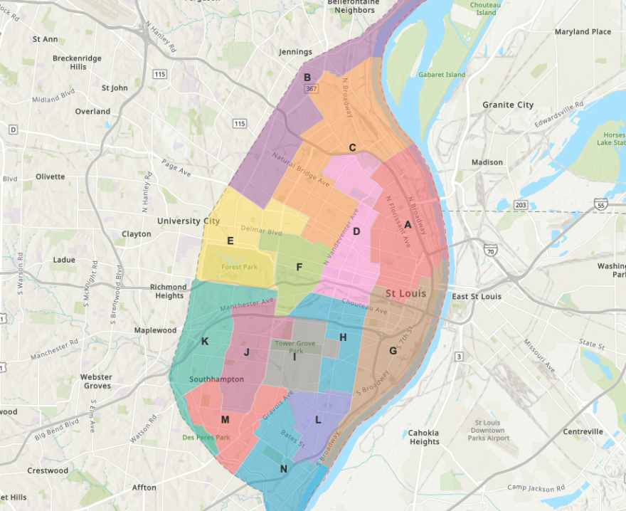
Updated Nov. 11 with the latest draft of the redistricting map
The St. Louis aldermanic committee overseeing ward redistricting released an updated map Thursday evening.
In the latest draft, wards, in particular north of Highway 40, have been shifted and compacted. The committee received many requests from the public to keep existing neighborhoods intact. Now, it says 80% of neighborhoods are in one ward, with the remainder in two wards. Some areas that are split include downtown and the south city Bevo neighborhood.
The map still has seven African-American majority population wards and seven white majority population wards. The committee is seeking community input on the latest draft in Zoom meetings scheduled for Saturday at 10 a.m. and Monday at 6 p.m.
Updated Nov. 10 after a meeting of the aldermanic legislation committee
Members of the St. Louis aldermanic legislation committee met briefly Wednesday to discuss ward redistricting in the city, saying they want to continue to work on tweaking the map throughout the day. They plan to release a third draft of a map Thursday on the city’s website.
The committee also agreed to hold community meetings to get public feedback on the new map on Saturday, with the time not yet set, and on Monday at 6 p.m.
The city’s website now has an interactive map of the second draft of the map, highlighting 14 new wards, down from the current 28.
Original story from Nov. 9:
The St. Louis Board of Aldermen is getting closer to finalizing a map that redraws the city with 14 wards, down from 28, as the deadline approaches to do so by the end of the year.
Board President Lewis Reed presented a new draft of a map to members of the legislation committee on Tuesday. He said it’s more user-friendly than the first draft released last week, allowing residents to zoom in to street level for their neighborhood. Reed said the goal is to keep neighborhoods together as much as possible and ensure equitable minority representation. In 2012, voters approved a city charter amendment to cut the number of wards in half.
Reed said the new map draft still shows seven minority preference wards and seven non-minority preference wards, as did the previous draft.
He said the committee is trying to accommodate recommendations from the community to keep certain neighborhoods together, adding that more than 160 people have provided comments through the city’s online portal for redistricting.
“People said that they'd like to see some more areas across the Delmar divide, connected in single wards to begin to eliminate that Delmar Divide. That's great information,” he said. “And by putting that into this whole dialogue, that's going to change the outcomes of what we're doing.”
Other commenters urged keeping neighborhoods such as Dogtown, Southampton and Bevo together. The new draft shows that Bevo and the Ville are still split between districts.
The map draft is to be available on the city’s website this afternoon. Residents will be able to download individual district maps as PDFs and can request a printed copy from City Hall. The new district information also includes population data, such as racial and age breakdowns.
Joseph Vollmer, legislation committee chair and 10th Ward alderman, said he wants to finalize the map as much as possible overnight through conversations with other aldermen and come back to the committee at 11 a.m. Wednesday with an updated draft.
He said there’s still work to be done on districts that break up the downtown and midtown areas. Plus, sprawling districts in north St. Louis need to be made more compact. However, one issue with that is uneven population density, with far fewer people living in north St. Louis. The committee is aiming for about 21,000 people represented in each ward.
“That’s the No. 1 thing I heard when people found out I was chairing this is — neighborhoods, neighborhoods, neighborhoods,” he said. “I think we’re being successful in that. We’re trying our best, but then we also have to make the racial parity and the numbers and the deviations work.”
The committee will continue to tweak the draft this week with a goal of having a close-to-final version available before Monday, when the committee plans to hold the next meeting for public comment.
A group of eight aldermen signed a letter published Monday calling for more transparency in the process, public input and better-quality maps.
The League of Women Voters, which has criticized the process, citing among other things a lack of transparency, will hold a press conference Wednesday afternoon to express its concerns. Representatives from the Coalition of Black Trade Unionists, the Missouri Asian American Youth Foundation, Compassion St. Louis and the Jewish Community Relations Council are also expected to speak at the press conference.
Several aldermen during the meeting Tuesday urged the public and those in opposition to the process to take a look at the new data and provide comments to help improve the map.
Follow Corinne on Twitter: @corinnesusan


